
The latest firmware v7.8 now has added map support (like the other Ultra firmwares). I found some black and white map tiles and decided to see how they'd look on the T-Deck Pro's monochrome e-paper display, and it looks quite decent.
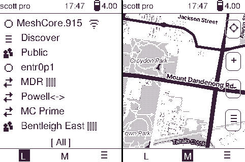
The home screen tabs have been moved to the bottom of the screen, instead of the left-hand side, but work the same as the other Ultra firmwares.
Downloading Map Tiles
The map tiles are by a commercial provider, so I can't offer these for resale in convenient ZIP files. But, they offer a free-tier which anyone can sign up for, and use their API to download select map tiles yourself. The map style is named Stamen Toner, and published by Stadia Maps.
Sign Up and get API Key
First sign up for free account. Once signed up, from the Dashboard, go to Manage Properties, scroll down and click on 'Create API Key'. Copy this key (you will need to paste it into a Python script below).
Edit Python Script
This script below can download a given lat/lon bounds and selected zoom levels, saving to /tiles directory on your computer's home directory.
import os
import requests
import time
from math import log, tan, cos, pi
from tqdm import tqdm
import shutil

# Define the bounding boxes and zoom levels   <------------- uncomment one of these, OR add your own bounding box
regions = {
#    "Victoria, central": (-38.82,143.74,-37.12,146.09)
#    "Victoria, SE": (-38.51,144.84,-36.69,147.25)
#     "Melbourne, East": (-38.03,144.85,-37.67,145.44)

#    "USA": (24.28,-125.57,49.62,-59.08)
#    "Alaska": (54.82,-168.99,71.53,-136.24)

#     "World": (-80.0,-170.0,80.0,170.0)

#     "Europe": (34.93,-11.36,62.46,39.98)

    "UK": (48.89,-10.77,59.86,1.93)
#    "Greater London": (50.62,-1.7,52.24,1.53)

#    "cbd": (-37.87, 144.91, -37.77, 145.03)
#    "Australia": (-44.46, 113.07, -10.21, 155.02)
#    "Argentina": (-55.96, -76.08, -21.09, -53.22)
#     "France": (41.78,-5.29,51.38,8.45),
#     "Germany": (47.24,5.6,54.95,15.45),
#     "Switzerland": (45.76,5.95,47.81,10.71)

#    "South-West USA": (28.63, -125.08, 42.26, -102.74)

#      "New Mexico": (31.27,-109.08,37.05,-102.91),
#      "Oklahoma and Nth Texas": (31.3,-102.91,37.09,-93.54),
#      "South Texas": (25.82,-100.35,31.3,-93.45),
#      "South-west Texas": (28.51,-106.29,31.3,-100.35)

#      "Florida-N": (29.03,-87.73,31.15,-80.8),
#      "Florisa-S": (24.23,-83.38,29.03,-79.76),

#      "Arkansas, Mississippi, Louisiana": (28.81,-94.63,36.7,-87.22),
#      "Georgia, Alabama, Sth Carolina, Tennessee": (30.64,-87.22,36.7,-78.91),
#      "Nth Carolina": (33.43,-78.91,36.64,-75.3)

#      "Missouri, Illinois": (36.5,-94.71,42.47,-87.49),
#      "Missouri, Iowa": (39.03,-96.69,43.57,-90.03),
#      "Kentucky, Indiana, Ohio": (36.44,-87.63,41.98,-80.38),
#      "West Virginia, Virginia, Maryland, Delaware": (36.44,-80.43,39.72,-74)

#      "New York, Pennsylvania": (39.61,-80.63,45.01,-73.27),
#      "Pennsylvania 2": (38.36,-75.78,39.77,-74.04),
#      "New England states": (40.35,-73.34,45.14,-69.49),
#      "Maine": (42.82,-71.71,47.55,-66.77)

#      "North-west USA (Oregon, Washington)": (41.92,-125.06,49.06,-116.6)

#      "Minnesota": (43.42,-97.19,49.08,-91.08),
#      "Wisconsin": (42.55,-91.17,48.3,-86.81),
#      "Michigan": (41.7,-87.97,46.64,-82.19)

#     "Idaho, Montana 1": (41.95,-117.15,49.04,-110.92),
#     "Montana 2, Wyoming": (40.92,-110.96,49.07,-101.9),
#     "Nth Dakota, Sth Dakota, Nebraska": (39.86,-102.14,49.05,-95.38),
#     "Colorado": (37.03,-109.12,41.01,-101.96),
#     "Kansas": (36.92,-102.05,40.08,-94.57)

}
zoom_levels = range(1, 7)  # <----- EDIT: start zoom, end zoom (second is exclusive)

# mapstyle = "cycle"
# mapstyle = "transport"
# mapstyle = "landscape"
mapstyle = "outdoors"
# mapstyle = "transport-dark"
# mapstyle = "spinal-map"
# mapstyle = "pioneer"
# mapstyle = "mobile-atlas"
# mapstyle = "neighbourhood"
# mapstyle = "atlas"

# API Key and output directory
api_key = ""   # <-------------- SET YOUR API KEY HERE

global_dir = os.path.join(os.path.expanduser("~"), "Documents", "tiles-greater-london")
output_dir = os.path.join(os.path.expanduser("~"), "Desktop", "tiles")
os.makedirs(output_dir, exist_ok=True)

def lon2tilex(lon, zoom):
    return int((lon + 180.0) / 360.0 * (1 << zoom))

def lat2tiley(lat, zoom):
    return int((1.0 - log(tan(lat * pi / 180.0) + 1.0 / cos(lat * pi / 180.0)) / pi) / 2.0 * (1 << zoom))

def download_tile(zoom, x, y):
    #url = f"https://tile.thunderforest.com/{mapstyle}/{zoom}/{x}/{y}.png?apikey={api_key}"
    #url = f"https://a.tile.openstreetmap.org/{zoom}/{x}/{y}.png"
    url = f"https://tiles.stadiamaps.com/tiles/stamen_toner/{zoom}/{x}/{y}.png"
    tile_dir = os.path.join(output_dir, str(zoom), str(x))
    tile_path = os.path.join(tile_dir, f"{y}.png")
    os.makedirs(tile_dir, exist_ok=True)

    if not os.path.exists(tile_path):
        g_dir = os.path.join(global_dir, str(zoom), str(x))
        g_path = os.path.join(g_dir, f"{y}.png")
        if os.path.exists(g_path):
            shutil.copy2(g_path, tile_path)
        else:
            headers = {'Connection': 'close', 'Accept-Encoding': None, 'User-Agent': None, 'Authorization': f"Stadia-Auth {api_key}" }
            response = requests.get(url, headers=headers)
            if response.status_code == 200:
                with open(tile_path, "wb") as file:
                    file.write(response.content)
            else:
                print(f"Failed to download tile {zoom}/{x}/{y}: {response.status_code} {response.reason}")

def main():
    total_tiles = 0

    for zoom in zoom_levels:
        for min_lat, min_lon, max_lat, max_lon in regions.values():
            start_x = lon2tilex(min_lon, zoom)
            end_x = lon2tilex(max_lon, zoom)
            start_y = lat2tiley(max_lat, zoom)
            end_y = lat2tiley(min_lat, zoom)

            total_tiles += (end_x - start_x + 1) * (end_y - start_y + 1)

    with tqdm(total=total_tiles, desc="Downloading tiles") as pbar:
        for zoom in zoom_levels:
            for min_lat, min_lon, max_lat, max_lon in regions.values():
                start_x = lon2tilex(min_lon, zoom)
                end_x = lon2tilex(max_lon, zoom)
                start_y = lat2tiley(max_lat, zoom)
                end_y = lat2tiley(min_lat, zoom)

                for x in range(start_x, end_x + 1):
                    for y in range(start_y, end_y + 1):
                        download_tile(zoom, x, y)
                        pbar.update(1)
                        # time.sleep(1)

if __name__ == "__main__":
    main()
You need to define a region (see the <--- comment in code), define zoom_levels (is an inclusive/exclusive range), and set api_key to the one generated for you (paste inside the double quotes at the <---- comment in code)
Then just run this script on your computer. Note, if you had to interrupt this script or something went wrong running it, you can run it again and it should resume from where it left off.
Copy to SD Card
Just copy the /tiles directory in your computer's home directory to a FAT32 formatted SD card (max 32Gb). Then insert into your T-Deck Pro, and reboot.