

‼ Bret stronger, now @ 65mph ‼
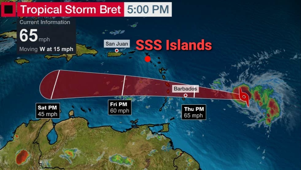
5pm stats on the CENTER of TS Bret:
> Location: 13.3°N 53.9°W
...or +/- 695mi SE of St. Maarten
...or +/- 690mi SE of Saba
...or +/- 670mi SE of St. Eustatius
> Winds: incr. to 65 mph
...Minor effects to the SSS Islands are expected from Thu afternoon -- which include Gusty Winds (20-25mph), Rough Seas (up to 10ft); then Thunder-Showers (some heavy) & poss. street-flooding on Fri & Sat.
...Major effects to the SE Caribbean are expected through Fri -- which include storm-force winds (40mph +), etc.
> it's moving: West @ 15mph
…Little change in strength is expected during the next day or so, while Bret approaches the Lesser Antilles, then weakening by Thu night or Fri -- after Bret passes through the Southern Caribbean.
> Watches & Warnings:
…Tropical Storm Warning is now in effect for: St. Lucia, Martinique.
⚠ A Tropical Storm Warning means that tropical storm conditions are possible within the warning area within 24-36hrs.
…Tropical Storm Watch is in effect for: Barbados, Dominica, St. Vincent & the Grenadines.
⚠ A Tropical Storm Watch means that tropical storm conditions are possible within the watch area within 24-48hrs.
>> The Center of Bret is expected at its closest to the SSS Islands on Fri morning -- as a strong tropical storm.
...Its CENTER is expected to pass (+/- 260mi) south of the SSS on Fri, while effects from its OUTER BANDS will likely be felt from Thu afternoon through Sat -- with improvements expected by Sun.
________________
Reminder:
* St. Maarten = 18.0°N, 63.1°W
* Saba = 17.6°N, 63.2°W
* St. Eustatius = 17.5°N, 63.0°W
________________
Next update: +/- 11:30pm (unless there are major changes @ 8pm)
#StayCalm #BeAlert #itCouldHaveBeenWorse