

 In an age where technology has transformed nearly every aspect of our lives, cycling has embraced the digital revolution with open arms. Gone are the days of paper maps and printed cue sheets—today's cyclists have access to sophisticated applications that transform smartphones and bike computers into powerful tour planning tools. Whether you're planning a weekend adventure, daily commute, or cross-continental expedition, the right app can elevate your cycling experience through detailed route planning, real-time navigation, and community insights.
This article explores five leading bike tour planning applications—Strava, Komoot, Google Maps, Maps.ME, and Cyclemaps—examining their unique features, strengths, weaknesses, and ideal use cases. By understanding the distinct capabilities of each platform, you can select the tool that best aligns with your cycling ambitions and navigation needs.
Strava: The Cyclist's Social Network
Originally launched as a performance tracking tool in 2009, Strava has evolved into a comprehensive platform that combines athletic data analysis with robust social networking features. For many cyclists, the orange icon represents more than just an app—it's a digital community where rides are shared, achievements celebrated, and routes discovered.
Strava's foundation remains firmly rooted in performance metrics. The application meticulously records speed, distance, elevation gain, heart rate (when paired with compatible devices), and numerous other data points that allow cyclists to track progress over time. This performance focus has made Strava particularly popular among fitness-oriented riders who view cycling through the lens of athletic development.
The platform's standout feature—Segments—transforms ordinary stretches of road or trail into virtual race courses where cyclists compete for rankings on leaderboards. This gamification element adds a competitive dimension to routine rides and has fostered a global community of cyclists striving to claim "King/Queen of the Mountain" titles on local climbs and sprints.
While Strava wasn't initially developed as a navigation platform, its route planning capabilities have expanded significantly in recent years. The Route Builder feature, available to premium subscribers, leverages the platform's vast repository of user activity to generate "heatmaps" that visualize popular cycling corridors. This crowd-sourced approach to route planning helps cyclists discover established riding routes, even in unfamiliar territory.
For touring cyclists, Strava's navigation features still lag behind more specialized applications. The platform offers basic turn-by-turn directions but lacks the detailed surface information and comprehensive offline capabilities that long-distance cyclists often require. Battery consumption can also be problematic during extended rides, as Strava's continuous GPS tracking and data processing demands significant power.
The application's integration with bike computers is a significant advantage for serious cyclists. Strava seamlessly connects with devices from Garmin, Wahoo, Hammerhead, and other manufacturers, enabling riders to record activities without draining smartphone batteries. This ecosystem approach extends to various sensors and wearables, creating a comprehensive fitness tracking environment.
Strava's premium subscription (branded as "Strava Subscription") unlocks additional features, including advanced performance metrics, training plans, and more detailed route planning tools. At $7.99 monthly or $59.99 annually, the subscription represents a significant investment for casual cyclists but offers substantial value for dedicated riders who leverage the platform's full capabilities.
In essence, Strava shines brightest as a performance tracking and social platform with supplementary navigation features. Its extensive user base—over 100 million registered athletes—creates a vibrant community where cyclists can find inspiration, motivation, and route suggestions. For performance-oriented riders who value data analysis and social connection, Strava remains the gold standard despite its navigation limitations.
Komoot: The Route Planning Specialist
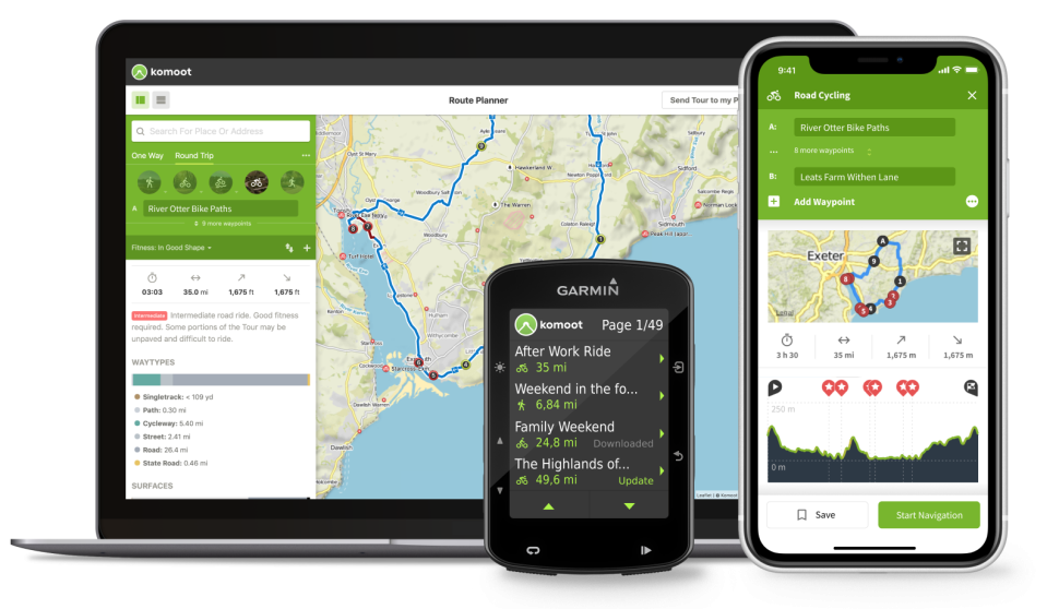
Where Strava approaches cycling primarily through the lens of athletic performance, Komoot positions itself as a specialized planning tool for outdoor adventures. Founded in Berlin in 2010, Komoot has earned a reputation for detailed route planning with an emphasis on surface information and terrain-specific guidance.
Komoot's core functionality revolves around intelligent route generation. Users can specify their preferred cycling discipline—road cycling, touring, mountain biking, or gravel riding—and the application algorithmically creates optimized routes based on surface type, elevation profile, and user preferences. This discipline-specific approach ensures road cyclists aren't inadvertently directed onto technical singletrack, while mountain bikers discover appropriate trail networks.
The platform's surface type visualization represents a significant advantage for touring cyclists. Routes are color-coded based on pavement, gravel, singletrack, or other surface classifications, allowing riders to make informed decisions about appropriate equipment and tire selection. This granular surface information proves invaluable for bikepackers and tourers traversing diverse terrain.
Navigation capabilities represent another Komoot strength. The platform offers clear, concise turn-by-turn directions that can be delivered via voice prompts, smartphone display, or connected bike computers. The voice navigation functionality proves particularly useful for urban riding, where frequent reference to visual displays might compromise safety.
Komoot's "Highlights" feature leverages community knowledge to identify noteworthy locations along potential routes. These user-submitted points of interest—scenic viewpoints, historic landmarks, challenging climbs, or cyclist-friendly cafés—add contextual richness to route planning and help riders discover local gems that might otherwise remain hidden.
The platform's pricing structure differentiates it from subscription-based competitors. While Komoot offers a premium subscription tier ($59.99 annually) with enhanced features, its core functionality revolves around regional map packages. Users can purchase individual regions for $3.99 each or invest in the "World Pack" ($29.99) for lifetime access to global maps. This one-time purchase option appeals to cyclists wary of recurring subscription fees and provides excellent value for frequent travelers.
Offline functionality represents another Komoot advantage. Routes and maps can be downloaded for offline access, ensuring navigation capabilities persist even in areas with limited cellular connectivity. This feature proves essential for remote touring and international travel where data connections may be unreliable or prohibitively expensive.
Integration with bike computers and smartwatches is well-executed, with direct support for major devices from Garmin, Wahoo, and other manufacturers. Routes created in Komoot can be seamlessly transferred to compatible devices, enabling navigation without smartphone use—a significant battery-saving advantage during extended tours.
Komoot's community aspect, while not as developed as Strava's social ecosystem, continues to expand. Users can share completed tours, follow fellow cyclists, and discover community-created routes. The platform's focus remains firmly on route planning rather than performance comparison, creating a collaborative rather than competitive atmosphere.
For cyclists prioritizing detailed route planning and navigation, particularly those embarking on touring adventures or exploring unfamiliar terrain, Komoot represents a compelling option. Its specialized focus on cycling-specific information, flexible pricing structure, and comprehensive offline capabilities make it the preferred choice for many serious bike tourers.
Google Maps: The Universal Navigator
Google Maps occupies a unique position in the navigation landscape. While not explicitly designed for cyclists, the platform's universal availability, comprehensive global coverage, and continuous development have established it as a default navigation tool for countless riders worldwide.
The platform's greatest strength lies in its ubiquity. Available on virtually every smartphone and regularly updated with the most current geographical information, Google Maps offers a familiar, reliable interface that requires minimal learning curve. For casual cyclists or those making spontaneous journeys, this accessibility represents a significant advantage over more specialized applications.
Google introduced cycling-specific directions in 2010, gradually expanding coverage to numerous regions worldwide. The platform intelligently routes cyclists along designated bike lanes, shared-use paths, and cycling-friendly streets when available, while avoiding highways and other unsuitable corridors. These cycling-specific algorithms have improved substantially in recent years, though coverage quality varies significantly by location.
Real-time information represents another Google Maps advantage. The platform incorporates current traffic conditions, temporary road closures, and construction alerts into its routing suggestions—dynamic elements that specialized cycling applications often lack. This real-time awareness proves particularly valuable for urban commuters navigating congested environments.
The platform's integration of Street View functionality allows cyclists to virtually preview unfamiliar routes, identifying potential hazards or navigation challenges before physical encounters. This visual reconnaissance capability proves especially valuable when planning rides in urban environments or assessing the suitability of unfamiliar roads.
Google Maps' massive points of interest database exceeds the capabilities of cycling-specific applications. Restaurants, accommodations, bicycle shops, and other services are comprehensively cataloged with operating hours, contact information, and user reviews. This extensive POI integration proves invaluable for touring cyclists seeking services along routes.
Integration with public transportation information represents another unique strength. Cyclists can plan multimodal journeys combining cycling with trains, buses, or other transit options—a feature particularly useful for commuters and bike tourers utilizing public transportation for portions of their journeys.
Despite these advantages, Google Maps presents significant limitations for serious cycling navigation. Offline capabilities remain restricted, requiring pre-downloading specific areas before entering regions without connectivity. The platform's elevation information, while improved in recent years, lacks the detailed visualization found in cycling-specific applications.
Battery consumption represents another concern for extended journeys. Google Maps' continuous internet connectivity and complex processing demands substantial power, potentially depleting smartphone batteries during long rides unless supplemented with external power sources.
Integration with dedicated cycling devices remains limited. While Google Maps can display on certain Garmin devices through ConnectIQ applications, native integration with bike computers is virtually nonexistent. Cyclists utilizing dedicated GPS devices typically must transfer routes through cumbersome workarounds or third-party applications.
For casual cyclists, urban commuters, and riders in well-mapped regions, Google Maps often provides sufficient functionality without additional applications. Its universal availability, real-time information, and comprehensive POI database make it an excellent starting point, particularly for riders unwilling to invest in premium cycling applications. However, serious tourers and those venturing into remote terrain will likely find its limitations frustrating compared to specialized alternatives.
Maps.ME: The Offline Specialist
Maps.ME (recently rebranded as MapsWithMe) emerged as a solution to a specific problem: how to navigate effectively without reliable internet connectivity. This focus on offline functionality has established the application as a favorite among international travelers, remote adventurers, and budget-conscious cyclists concerned about data usage.
The platform's fundamental architecture differs from most competitors. Rather than streaming map data continuously, Maps.ME allows users to download comprehensive regional maps for offline use. These vector-based maps consume relatively little storage space while providing detailed navigation capabilities without internet connectivity—a crucial advantage for cyclists touring through remote areas or international territories where data roaming proves prohibitively expensive.
Maps.ME's utilization of OpenStreetMap data represents both strength and limitation. This crowd-sourced mapping project often contains remarkably detailed information about cycling infrastructure, particularly in regions with active OSM communities. However, coverage quality varies dramatically between regions, potentially creating information gaps in less-documented areas.
The application's user interface prioritizes simplicity and efficiency rather than comprehensive feature sets. This streamlined approach translates to minimal battery consumption—a significant advantage during extended tours where power conservation remains critical. The lightweight design also enables smooth operation on older smartphones that might struggle with more resource-intensive applications.
For cyclists, Maps.ME offers basic routing capabilities with cycling-specific options. While lacking the sophisticated discipline-specific algorithms found in specialized applications like Komoot, the platform generally avoids routing cyclists onto prohibited roads and attempts to utilize available cycling infrastructure. Elevation information, when available, is displayed in a basic profile view.
The platform's bookmarking system provides a straightforward method for marking important locations—accommodation, water sources, bike shops, or other services—during tour planning. These bookmarks remain available offline, creating rudimentary route planning capabilities for cyclists venturing beyond cellular coverage.
Maps.ME's pricing represents another significant advantage. The basic application is available without cost, with revenue generated through unobtrusive advertisements. A premium subscription ($9.99 annually) removes advertisements while supporting continued development. This accessibility makes Maps.ME particularly attractive for budget-conscious cyclists.
Integration with cycling-specific devices remains minimal. The platform offers basic GPX import/export functionality, but direct communication with bike computers is generally unsupported. This limitation reinforces Maps.ME's position as a smartphone-based navigation solution rather than a comprehensive cycling ecosystem.
For certain cycling demographics—particularly long-distance tourers traversing multiple countries, bikepackers venturing into remote regions, or budget travelers minimizing data usage—Maps.ME's focused approach to offline navigation provides essential functionality. While lacking the cycling-specific sophistication of specialized alternatives, its reliability in connectivity-challenged environments earns it a place in many touring cyclists' navigation arsenals.
Cyclemaps: The Infrastructure Specialist
Completing our comparison is Cyclemaps—a relatively recent entrant focused specifically on helping cyclists navigate using dedicated cycling infrastructure. This specialized approach addresses a common frustration: mainstream navigation applications often route cyclists along roads optimized for vehicular traffic rather than dedicated cycling corridors.
Cyclemaps leverages OpenCycleMap data—an OpenStreetMap derivative emphasizing cycling infrastructure—to highlight bike lanes, cycle tracks, shared-use paths, and other cycling-specific routes. This infrastructure focus proves particularly valuable in urban and suburban environments where dedicated cycling facilities create safer, more enjoyable riding opportunities that general navigation applications might overlook.
The platform's route generation algorithm heavily prioritizes separated cycling infrastructure and quiet streets over busy roadways, even when such preferences might increase journey distance. This safety-oriented approach resonates particularly with commuters, families, and recreational cyclists who prioritize comfortable riding environments over absolute efficiency.
Elevation visualization represents another Cyclemaps strength. Routes display clear elevation profiles with gradient information, helping cyclists anticipate challenging climbs or descents. This elevation awareness proves particularly valuable for e-bike users managing battery consumption and cyclists with physical limitations who might prefer flatter terrain.
The application's database of cycling-specific points of interest exceeds most competitors. Bike parking facilities, public repair stations, water fountains, and bicycle-friendly businesses are prominently displayed, creating a comprehensive ecosystem of cycling services often absent from general navigation platforms.
Weather integration provides another practical dimension for tour planning. Cyclemaps incorporates forecasted conditions into route suggestions, helping cyclists avoid potential weather-related challenges. This forward-looking approach proves particularly valuable for commuters and recreational riders planning outings several days in advance.
Cyclemaps offers reasonably robust offline capabilities, though not as comprehensive as Maps.ME's fully offline approach. Routes and maps for specific regions can be downloaded for use without connectivity, providing essential navigation capabilities in areas with limited cellular coverage.
Integration with cycling devices has improved significantly in recent development cycles. The platform now offers direct connectivity with several Garmin and Wahoo models, enabling route transfer without smartphone dependency. This expanded device ecosystem increases Cyclemaps' appeal for cyclists utilizing dedicated GPS units.
The platform's pricing structure balances accessibility with sustainable development. A free tier provides basic functionality with advertisements, while premium subscriptions ($4.99 monthly or $39.99 annually) unlock advanced features including unlimited offline maps, advanced routing options, and weather integration.
For urban cyclists, commuters, and riders prioritizing dedicated infrastructure, Cyclemaps offers specialized functionality often absent from broader navigation platforms. Its focused approach may lack the comprehensive feature sets of larger competitors, but its infrastructure emphasis addresses a specific navigation need underserved by mainstream alternatives.
Choosing the Right Tool for Your Cycling Journey
The optimal navigation application ultimately depends on your specific cycling priorities, technical requirements, and budget constraints. Many serious cyclists utilize multiple platforms for different scenarios—perhaps Strava for performance tracking, Komoot for detailed tour planning, and Maps.ME as a reliable offline backup for remote adventures.
For performance-oriented cyclists who view riding primarily through athletic and social lenses, Strava remains the definitive platform despite its navigation limitations. Its comprehensive metrics, segment challenges, and vibrant community create an engaging ecosystem that transforms ordinary rides into shared experiences and virtual competitions.
Touring cyclists undertaking multi-day journeys, particularly those crossing diverse terrain types, will likely find Komoot's sophisticated planning capabilities and detailed surface information indispensable. Its one-time purchase option for global maps provides excellent value for frequent travelers, while comprehensive offline functionality ensures reliability in connectivity-challenged environments.
Urban commuters and casual cyclists navigating familiar territories may find Google Maps entirely sufficient. Its universal availability, real-time information, and comprehensive points of interest database provide practical navigation without additional applications. The platform's integration with public transportation information creates particularly valuable functionality for multimodal commuters.
Adventurous cyclists venturing into remote regions or international territories where reliable connectivity cannot be assumed will appreciate Maps.ME's committed approach to offline functionality. Its lightweight design and minimal battery consumption prove especially valuable during extended tours where power conservation remains critical.
Riders prioritizing dedicated cycling infrastructure, particularly in urban and suburban environments, will find Cyclemaps' specialized focus addressing navigation needs underserved by mainstream platforms. Its emphasis on separated facilities and quiet streets resonates with safety-conscious cyclists seeking comfortable riding environments.
As cycling technology continues evolving, these platforms will undoubtedly expand their capabilities while new contenders emerge to address specific navigation challenges. The ideal approach involves experimenting with several options during low-consequence rides, identifying which interfaces and feature sets align with your particular cycling style and navigation requirements.
Ultimately, these digital tools should enhance rather than dominate the cycling experience—providing confidence to explore new territories, discover engaging routes, and navigate efficiently while maintaining connection with the fundamental joys of cycling: freedom, discovery, and the simple pleasure of traveling under your own power.