

TLDR: French tidal stream atlases here.
France has adopted a robust approach to opening up access to government data - making open access a default policy. A 2019 letter by the French Prime-minister reiterates the policy in no uncertain terms:
I consider that data must now be seen as an essential and critical infrastructure for the functioning of the economy and the State…
Under these conditions, it is necessary to ensure that the provision of this data cannot be interrupted, whether it is unintentional failures or malicious acts….
As such, I asked the General Inspectorate of Finance… to draw up a first assessment within six months of the implementation of data openness and its impacts, the difficulties encountered by the ministries and their operators and to propose adapted accompanying measures.
The letter goes on to make clear that certain government departments, including the IGN (French mapping agency, like our OS) and Météo-France (weather service) must forge ahead with making their data freely available. It recognises that this will lead to losses of revenue for these departments (e.g. half a million euros just from the national postal address database), but basically instructs the departments in question to get on with it and to come up with new business models.
The French Hydrographic office (SHOM), being a government department, is also mandated to open up its data. Happily, this means that hydrographic information that used to be behind paywalls is now accessible for free.
One data set of particular interest to kayakers is the 'Courants de marée 2D', which includes information on tidal streams for the entire west coast of France. It's the basis of the (impressively detailed) tidal atlases published by SHOM. And it's now available under an open data license.
There's obviously a fair bit of work to do to convert the raw data files into tidal stream atlases. They need processing out of the rather odd format that they're supplied in. Map data of coastlines (also now available under open licenses) need to be obtained and sliced up. The map data and the tidal stream data need to be merged into well formatted plots and displayed in a sensible way.
All that has taken me some time, and I've had to learn a fair bit about Quarto, ggplot and Latex along the way, but I've now completed a first version of 'Tidal streams of Atlantic France'. You can find it here.
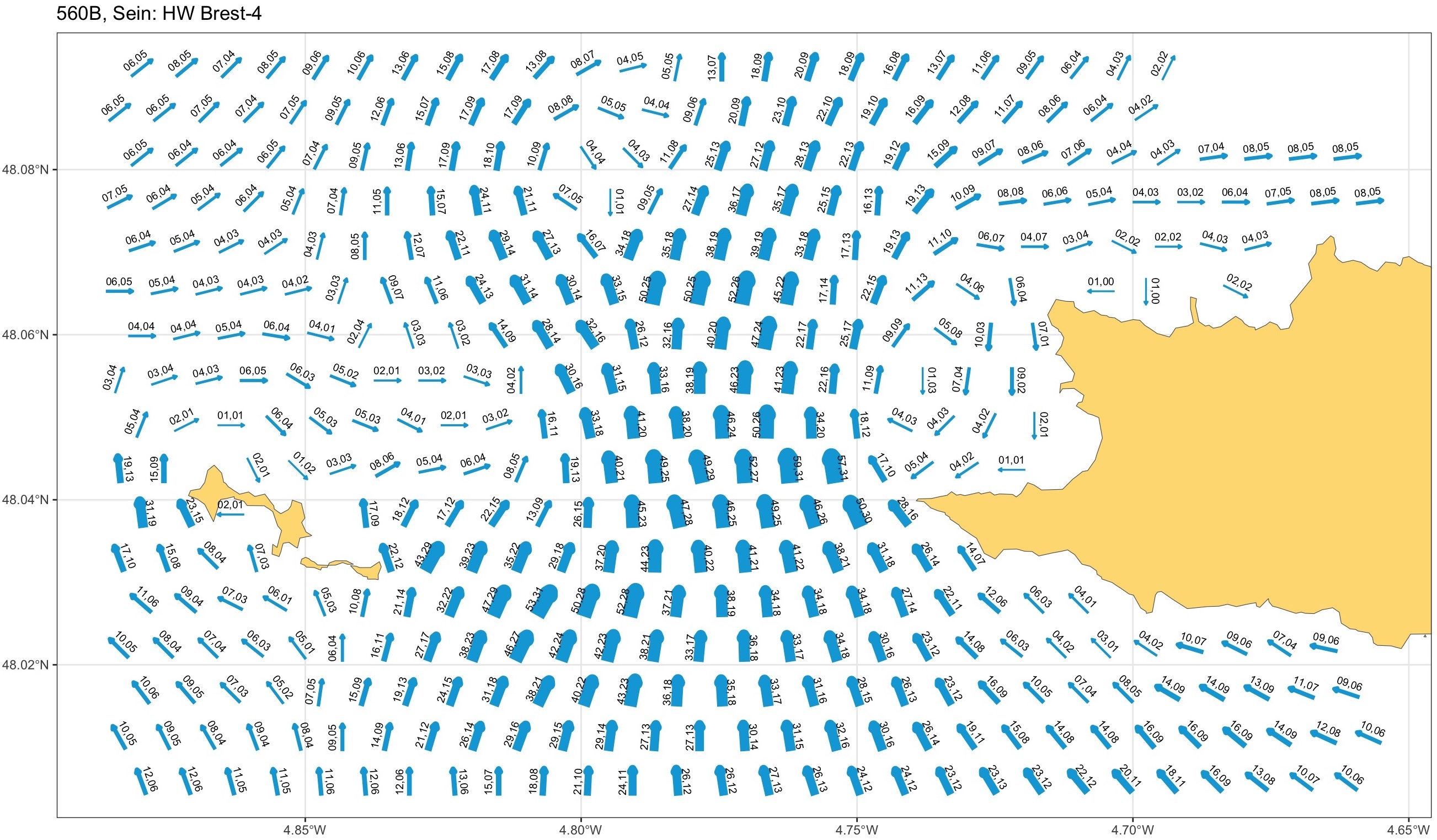
The PDF book contains the same data as 9 or so separate SHOM publications. It includes 40 different maps, each shown at 13 hours of the tide. The PDF runs to over 500 pages. Here's just one of the map instances, showing the Raz de Sein. The distance from the point to the island is just under 7km.
Whilst it's been a fair bit of work to put this together, the real credit must go to the French. SHOM's decision to use simulation to collate their tidal atlases has resulted in a level of detail and precision that makes the equivalent UKHO publications look rather outdated. And we've probably got a lot to learn from the French government's attitude to open data too.
Liberté, égalité, fraternité and happy paddling!